How’s the view? Bringing Drone Technology to the Farm
Drones are becoming both a popular toy and tool. The question for us is, can this technology do anything new for us as farmers?
 Three years ago, we purchased one of the more inexpensive drones just to get a feel for using it and to explore what it could do for us. It was rather basic and would take a few still photos. While it was fun to get a birds’ eye view of the farm and fields, it didn’t answer our main questions as to the benefits it would provide in monitoring crop health.
Since then, we have purchased a second drone with the capability to take many photos, and through software, stitch the photos together to get a view of an entire field. While the technology is fascinating, we still have a way to go in determining how we can best utilize this as a tool.
Seeing Potential Uses
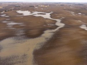
One way we are seeing its value is in viewing drainage patterns in a field. Since this was a particularly wet spring and early summer, we’ve noticed some areas where we thought we understood how the water drained, only to find out it wasn’t exactly accurate.
With that information, we can make a better-informed decision on how to improve drainage over the next year. We always want to improve drainage in our fields, and for many farmers this year, it was evident how crucial water control is; many low-lying areas held water for over a week, and many had to replant, or perhaps lost some of their crop early on.
It’s difficult to put a dollar value on this information, but it does help us prioritize our off-season ground work that will ultimately improve next years’ crop.
Another way we are exploring drone technology is to monitor crop health. We are able to take photos both in a normal RGB photo format and as an NDVI. NDVI is similar to near infrared, capturing the reflection of the chlorophyll in a plant which allows us to see the overall health of a crop.

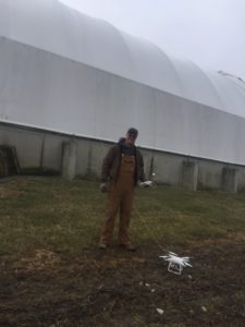
Dean’s son, Adam – Our number one drone pilot. In this picture, he flew the drone over a building with a string attached to it so we could measure the roof for a replacement cover.
We have a test field where we varied the application of nitrogen that should show up as various strips in the field. We will photograph the field once a week from now until crop maturity and then use the images to validate which nitrogen application did the job.
The drone can cover a 100-acre field in about 20-25 minutes; the uploading, stitching and downloading of the final images is about a 24-hour turnaround.
We’re Still Viewing This from All Angles
For now, we still have some learning to do and details to work out. Currently, there isn’t a way to standardize and compare fields. That means the color scale we see on one field can’t be compared to another. It does still give us a good understanding of how plant health varies within the one field.
Overall, the ag industry is still asking the same question and learning how best to utilize this tool. Even drone proponents agree that other factors, such as soil, fertility, and other problems are not discernible through aerial photos.
How’s the view? We’re still assessing it. While the drone has the potential to be a reliable tool, it still doesn’t replace walking the field to get a closer look on all the factors that affect crop production. No doubt, it’s just the beginning. The next generation of Lambs are eager to embrace technology, something that will benefit not only our operations, but everyone’s future.

